Britain’s landscape is far more dramatic than its modest size suggests. Within a few hours you can travel from sea‑level marshes to mountain ridges, from sunken fenland to windswept moorland. This guide explores the UK’s elevation extremes — the highest and lowest places in the country — all of which you can explore on our map.
Every location listed here is real, measurable, and part of the UK’s official topography. No folklore, no exaggeration, just geography.
1. Highest Peaks in the UK (with Infographic)
The UK’s highest mountains vary by nation, but all are dwarfed by the world’s tallest peak. Here are the national high points:
- England: Scafell Pike — 978m
- Wales: Yr Wyddfa (Snowdon) — 1,085m
- Northern Ireland: Slieve Donard — 850m
- Scotland: Ben Nevis — 1,345m
To put these into perspective, here they are compared to Mount Everest (8,848m):
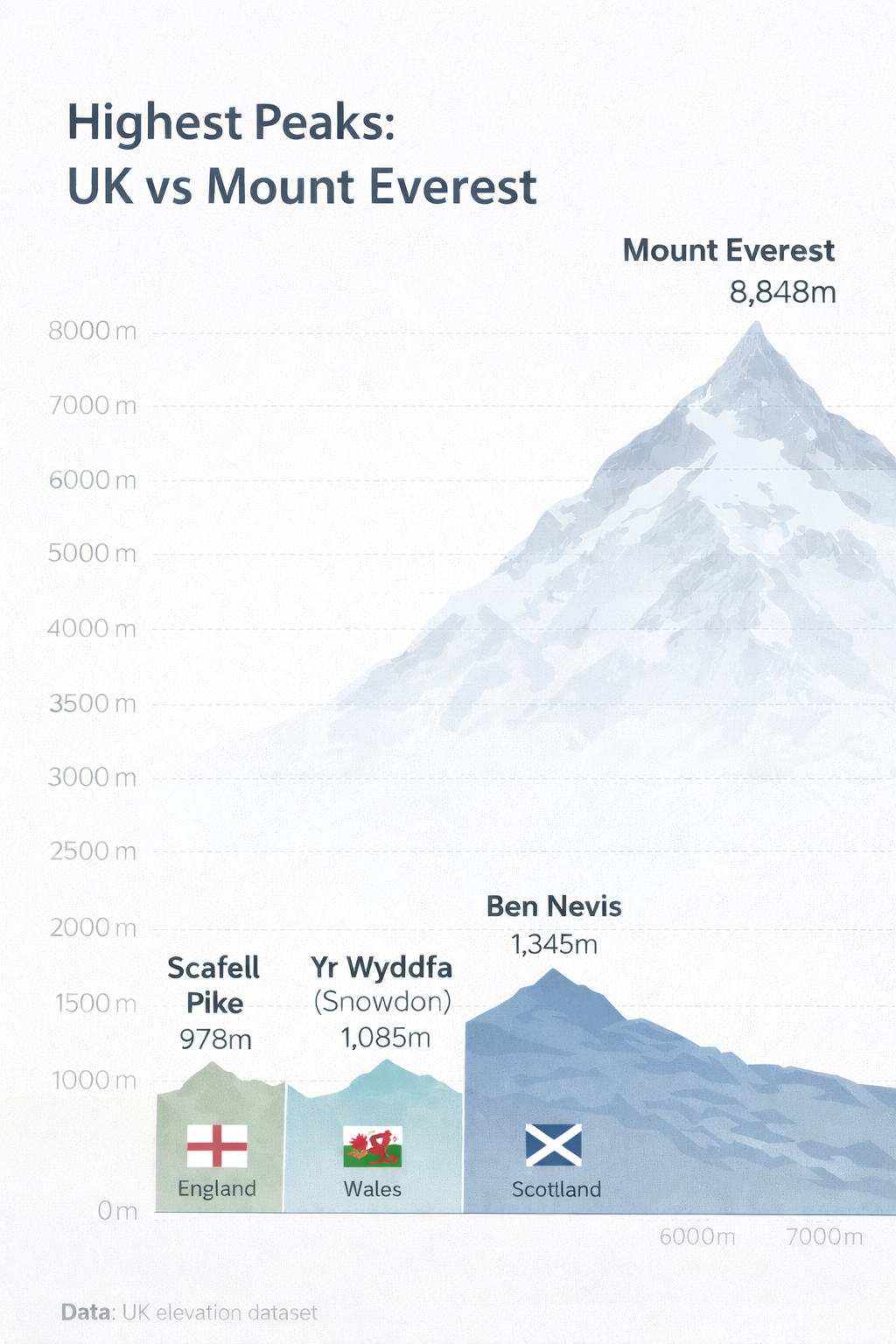
Even our tallest peaks look modest next to Everest, but the UK’s compact geography means you can reach dramatic landscapes without travelling far.
2. Highest Settlement in the UK
According to our elevation database, the highest inhabited settlement in the UK is:
Highest Settlement
Coalcleugh, Northumberland — 508m (1,667 ft)
A remote former mining locality in the North Pennines, Coalcleugh sits higher than any other settlement in Britain. It’s exposed, isolated, and beautifully bleak — exactly what you’d expect from the top of England.
Other high settlements in our data:
| Rank | Settlement | Elevation | County |
|---|---|---|---|
| 1 | Coalcleugh | 508m | Northumberland |
| 2 | Dunandhu | 482m | Aberdeenshire |
| 3 | East Bank | 477m | Blaenau Gwent |
| 4 | Killhope | 477m | County Durham |
| 5 | Hilltop | 477m | Staffordshire |
| 6 | Flash | 466m | Staffordshire |
What about Flash and Wanlockhead?
Flash and Wanlockhead both traditionally claim the title of “highest village”, but their elevations are lower than Coalcleugh in our dataset. The difference usually comes down to how “village”, “hamlet”, and “locality” are defined.
3. Highest Town in the UK
Buxton, Derbyshire — ~300m
Buxton is widely regarded as the highest market town in England, known for its Georgian architecture and natural spring water.
Other contenders include:
- Alston, Cumbria — 300m+
- Cwmystwyth, Ceredigion — 300m+
Definitions vary depending on population, charter status, and settlement boundaries.
4. Highest Roads in the UK
Highest public road:
Cairnwell Pass (A93), Scotland — 670m
The highest main road in the UK, crossing the Grampian Mountains.
Highest paved road (restricted access):
Great Dun Fell Radar Road — 848m
A tarmac road leading to an air‑traffic radar station. Cyclists love it; drivers are not allowed.
5. Lowest Point in the UK
Holme Fen, Cambridgeshire — −2.75m below sea level
The lowest natural point in Britain. The land here has sunk dramatically due to historic peat drainage — a process still ongoing.
A cast‑iron post installed in 1851 shows how far the ground has dropped since Victorian times.
6. Lowest Settlements in the UK
Several villages in the Fens sit at or below sea level, including:
- Sutton Gault
- Welney
- Christchurch
Exact rankings vary because the land continues to subside, but all are among the lowest inhabited places in Britain.
7. Lowest Road in the UK
A1101 near Welney — below sea level
This road regularly floods because it sits lower than the surrounding rivers. It is the UK’s lowest classified road and one of the few that can be underwater without anyone being especially surprised.
8. Coastal Extremes
Highest coastal cliffs:
Conachair, St Kilda — 430m
Among the highest sea cliffs in Europe.
Lowest coastal point:
Sea level — naturally — but Britain has quirks such as:
- The Broomway, Essex: a tidal path across the sands, often called “the most dangerous footpath in Britain”.
9. Fun Elevation Facts
- Scotland dominates elevation — in fact, the UK’s top 50 highest mountains are all found here.
- The Fens are sinking — peat shrinkage means some areas drop a few millimetres each year.
- “Highest village” is surprisingly political — Flash and Wanlockhead have traded claims for decades.
- Britain’s mountains are ancient — many are remnants of long‑eroded ranges or volcanic activity.
10. Summary Table
| Category | Location | Elevation |
|---|---|---|
| Highest point | Ben Nevis | 1,345m |
| Highest in England | Scafell Pike | 978m |
| Highest in Wales | Yr Wyddfa (Snowdon) | 1,085m |
| Highest in Northern Ireland | Slieve Donard | 850m |
| Highest settlement | Coalcleugh | 508m |
| Highest town | Buxton | ~300m |
| Highest public road | Cairnwell Pass | 670m |
| Highest paved road (restricted) | Great Dun Fell | 848m |
| Lowest point | Holme Fen | −2.75m |
| Lowest settlements | Fenland villages | Below sea level |
| Lowest road | A1101 | Below sea level |
Final Thoughts
The UK’s elevation extremes tell a story of geology, climate, and centuries of human adaptation — from mountain passes to reclaimed marshland. Whether you’re exploring the highest peaks or the lowest fens, every point on the map has a history behind it.